
| SRGMS Newsletter | August 2007 |
|
Bodega Headlands- Bodega Bay, CA 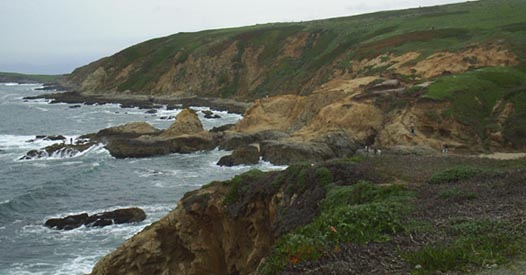 The History: Although occupied by the Coastal Miwok Indians, it is Spaniard captain, Juan Francisco de la Bodega y Quadra, who is credited with the "discovery" of Bodega Harbor in 1775. Due to is shallow lagoon and narrow harbor, the Bodega Port (now Bodega Harbor), was noted to only be used by small vessels. From 1812-1814 the harbor was renamed the Bay of Count Rumianstof in honor of the Chancellor of the Empire during the Russian expedition. In 1837, three British sailors were sent by General Vallejo to prevent further Russian expansion. By the late 1800's, Stephen Smith established several industries developing the area into a port village. Although he mainly transported produce and timber to San Francisco he is also credited with establishing a small fleet of fishing boats. Russian potato cultivation and cattle overgrazing by Swiss dairymen, lead to the sheet erosion and contributed to the silting up of Bodega Harbor. Major rehabilitation of channels during the late 1950's occurred to transform the harbor into the small fishing community we have today. Geological Features: The Bodega Bay is of considerable geological significance of the Sonoma coastline for it is partly controlled by the San Andreas Fault zone. Bodega Bay represents a northerly continuation of the Tomales Bay depression. Both Tomales and Bodega Bays are oriented along the alignment and contained within the limits of the San Andres Fault zone. The geology of the Bodega Head area was first investigated by V.C. Osmont who in 1905 proposed the term "Bodega diorite" for the exposed granitic rocks of the headlands. Radiometric dating indicates the rocks are 80-90 million years old. Bodega Harbor is floored with fine-grained sand, silt and clay and rises to a maximum elevation of 266 feet near the southern extremity. Bodega Bay is a typical hooked bay, subject to waves from a predominant direction. The eroding headland cliffs supply sand to the area at slow yet geologically significant rate. Heavy mineral analysis of the sediments proves that the granitic diorite Head slowly feeds certain natually radioactive materials into the near shore area as a result of wave erosion.
http://www.terrywrightgeology.com/bodega.html To read the full article on the History of Bodega Harbor 209.133.53.139/pdf/bodegabay.pdf Directions: From Santa Rosa, take Hwy 12 West towards Sebastapol, this will turn into Bodega Ave, and Bodega Hwy. Make a right turn onto Hwy 1 and pass the town of Bodega Bay. Just outside of town, after a sharp turn, make a left onto East Shore Road. At the stop sign make a Right onto Bay Flat Road which turns into West Shore Road. and follow it around the harbor and over the hill to the right coastal edge of Bodega Headlands.A large parking lot is available.
|
|
|||||||||

 We love to have more active members. Attend one or more of the SRMGS Meetings to get the most out of your membership! Meetings are held at the SRMGS Workshop.
|
In The News... WHEN THE EARTH MOVED: SONOMA COUNTY GEOLOGY REVISITED Press Democrat Posted: 10-1-1998 "Evidence of earth movement is everywhere, in the hills and the valleys and the rocks," said Sonoma State University Professor Terry Wright. From the jagged coastal rocks to the slopes of the once-volcanic Sonoma Mountain, most of the terrain was created by the same thing that causes earthquakes? the movement between mas-sive rock plates beneath the earth and sea Geologically, the Sonoma County landscape is like a reckless adoles cent?oung, dramatic and full of pent-up energy that periodically erupts or breaks apart?making for ongoing changes in the rugged hills and canyons. One way to understand the dynamic forces behind Sonoma County's geology is to picture two blocks of moving rock. Sometimes one slips under the other lifting it up. And sometimes they move in opposite directions. The movement causes shaking and rumbling?ut all that slipping and sliding also causes changes in the landscape.
Consider the following geological facts:
It's a challenge to try and picture the slow, complex underground action that over millions of years shaped the landscape. But the results are everywhere to see and touch "Shield volcanoes" Terry Wright began one of his recent geology tours on Sonoma Mountain, at a point on Lichau Road, off Petaluma Hill Road, where he picked up basalt rocks mottled by odd little holes, created by gas bubbles that formed inside what was hot nowing lava 3 to 5 million years ago. While holding in his hand proof of that long-ago eruption, Wright acknowledged that most people don't think "aha! volcano" when they look at the low meandering series of hills between Petaluma and Sonoma. Wright explained that's because this is a lesser known shape than the classic volcano cone. "The Sonoma Volcanics are 'shield' volcanos, low and spreadout because the lava nowed so fast," he said. The presence of large amounts of tuff in the volcanic sequence of Sonoma Mountain suggest that more explosive volcanic activity was present here. So this may not have been a classic shield volcano. The main uplift of these ranges seems to be along faults, compressional thrust types that have pushed the volcanics upward Mount Konocti has the more classic rugged cone shape and is still on the active list because it erupted "recently" in geologic time, that is about 10,000 years ago. Relics of the lava flow's scorch have become one of Sonoma County's tourist attractions, the "Petrified Forest". There you can see trees that were felled and preserved. "The Petrified Forest has trees 100 feet long that were once buried by volcanic ash. An earthquake fault indirectly gets credit for those petrified trees. Wright explained that the volcanos erupted when the earth's ocean floor plate to the west dragged deep down into the mantle of the earth, where it melted and turned to magma (molten rock). Evidence that hot magma continues flowing not too far under the surface of the North Coast is erupting daily as puffs of steam billow up along the Sonoma/Lake county line. "The Geysers is the result of magma that exists under Clear Lake. The Geysers is the largest commercial geothermal field in the world. It's like a big underground teapot," said Wright. Plate movement also explains why a vast area of western Marin and Sonoma counties are now dry instead of underwater like they were five million years ago. One plate moved pushed horizontally past another along the San Andreas fault. This fault motion has a compressional component which forces the land east of the fault upward along low angle thrust faults, lifting the earth, causing inland areas to rise, draining the inland sea. The parts of Sebastopol and Petaluma that once were underwater came to have the fich sandy loam soil, which attracted famed horticulturist Luther Burbank a century ago and later nourished the apple industry. Other remnants of the inland sea are oddly shaped sandstone rocks near the coast, including the "elephant rock" at Dillon Beach, also made from ocean bottom sand. And if you look closely at the rocks along Fallon-Tomales Road, you can see the patterns of ancient sealife in fossil form. The farther you travel west in Sonoma County, the bigger the chunks of above-ground earthquake evidence. Bodega Head is the prize. This peninsula that forms the northern border of Bodega Bay once was part of the Tehachapi Mountains in Southern California. "I tell people right off the bat that Sonoma County geology is schizophrenic. There are two distinct geologies, and the San Andreas is the dividing line," said Wright. The San Andreas is the major dividing point between the North American Plate, which extends from the West Coast across the continent to the middle of the Atlantic, and the Pacific Plate, under the Pacific Ocean. Bodega Head's big chunk of 100-million-year old granite is on the Pacific Plate, on the west side of the San Andreas, moving north. It has moved up the 320 miles from the Tehachapis, earthquake by earthquake. The last big move was 15 feet in the 1906 quake, Wright said. The movement of Bodega Head demonstrates the side-by-side movement of the plates. Go north for evidence of the other kind of plate movement with one plate moving under the other, Wright explained. At Shell Beach, rock collectors find evidence of how the Pacific Plate pushed under the North American Plate between about 120 and 40 million years ago, long before the San Andreas fault started its northward horizontal slide. Metamorphism deep in this subduction zone occurred with great pressure at low heat. The rocks here are different than at other beaches, with a lot of serpentine, blue schist and chert. The earth-movement action of one plate going under the other, called "subduction" ended about 10 million years ago when the plates started moving side-by-side along the San Andreas Fault. "The older rocks east of the San Andreas fault are completely different than the rest," said Wright. The geologic story moves into the modern day with landslides. The houses teetering on an eroding cliff at Gleason's Beach are on soil has been pulverized by the grinding plates, which made the individual grains so sheer and fine that they absorb water and turn into something known as "melange" which is very weak like clay, Wright explained. The same kind of melange makes up the hills around the Russian River, including in the Rio Nido canyon that where a horizontal block of weathered sandstone moved along a melange zone to cause a fluid debris flow under El Nino's deluges, Wright said. The San Andreas is the big one, but there are hundreds of other faults in this region. "It's like a plate of glass that has one major break but cracks and splinters all around the edge," Wright said. There's no crystal ball for the geologic future, but the past offers some hints about what might happen in the future. Along the North Coast, Wright says Bodega Head will continue its slow migration toward Oregon and the coastline will continue to be pushed up along the San Andreas fault and probably. "Highway 1 in a million years will be at least 600 feet higher than it is now, I guarantee you," said Wright. "But if in a million years it's not, don't come back and say 'I told you so.' " "California has the most exciting geology in the universe because of the constant uplift and fault movement," he said. "Our wonderfully diverse landscape is because of the geology." Wright, 55, has been teaching at Sonoma State University and exploring geology in the area for 29 years hiking up active land slides to see how they're moving, finding fossils in the most unlikely places, examining the rocks to learn what happened millions of years ago under the Earth's surface. The professor also leads tours and classes for the general public through Sonoma State University, Santa Rosa Junior College's Community Education Program, and the California Academy of Sciences. |
| SRGMS Newsletter | Continued |
|
Fees are based upon $10/hr instruction. 30% of all class fees are turned over to SRMGS.
Geology Topics 1 1/2 hours
Beginning Lost Wax 12 hours
Stone Carving 6 hours
Intermediate Lost Wax 9 hours
|